.png)

In recent years, wildfires have become an increasingly serious issue across Bulgaria, particularly during the summer months when high temperatures, dry conditions, and difficult terrain can accelerate both detection and response challenges. In that context, a local municipality needed a more reliable way to detect, track, and coordinate wildfire incidents. We designed and implemented an integrated map-based solution combining QGIS, Mergin, Make.com, PythonAnywhere, and NASA FIRMS (MODIS) to support both field teams and central administration. The final system brings together manual incident reporting, field updates, satellite-based detections, offline map access, and structured operational workflows into one environment.
The challenge
Wildfire response depends on fast access to accurate information. In practice, municipalities often receive incident data from multiple disconnected sources, including manual reports, field observations, phone calls, and external monitoring systems.
Without a unified workflow, it becomes difficult to maintain a clear operational picture, verify incoming signals, and coordinate teams efficiently.
The municipality needed a system that could centralize wildfire-related information in one GIS (Geographic Information System) environment, support both administration and field teams, work in areas with limited or no internet access, include automated satellite-based fire detections, and maintain a clear distinction between reported incidents and unverified satellite signals.
The solution
We developed a wildfire monitoring and coordination workflow built around a centralized GIS environment.
The architecture combines QGIS as the central operational map, Mergin for field data entry and synchronization, Make.com for the NASA FIRMS integration workflow, PythonAnywhere for hosting the QGIS-ready satellite layer, MBTiles for offline basemap access, and structured administrative controls for incident management.
This setup allows the municipality to bring together operational reports and automated detections in a single map-based workflow while keeping the system practical for day-to-day use.
System architecture
QGIS as the operational center
The QGIS desktop project serves as the central environment for monitoring incidents, reviewing statuses, and coordinating response activities. It gives the administration a unified view of all active records across the municipality.
Mergin for field operations
Mergin was implemented as the field collaboration layer. Teams in the field can create or update incidents, attach photos, add notes, and sync their changes back to the shared GIS project.
.jpeg)
Make.com & Python Anywhere for automation
The integration with NASA FIRMS (MODIS) is orchestrated in Make.com, which handles the recurring retrieval and automation workflow.
The processed satellite output is served through PythonAnywhere, where the QGIS-ready layer is hosted and made available for visualization inside the desktop GIS environment.

Key functionality
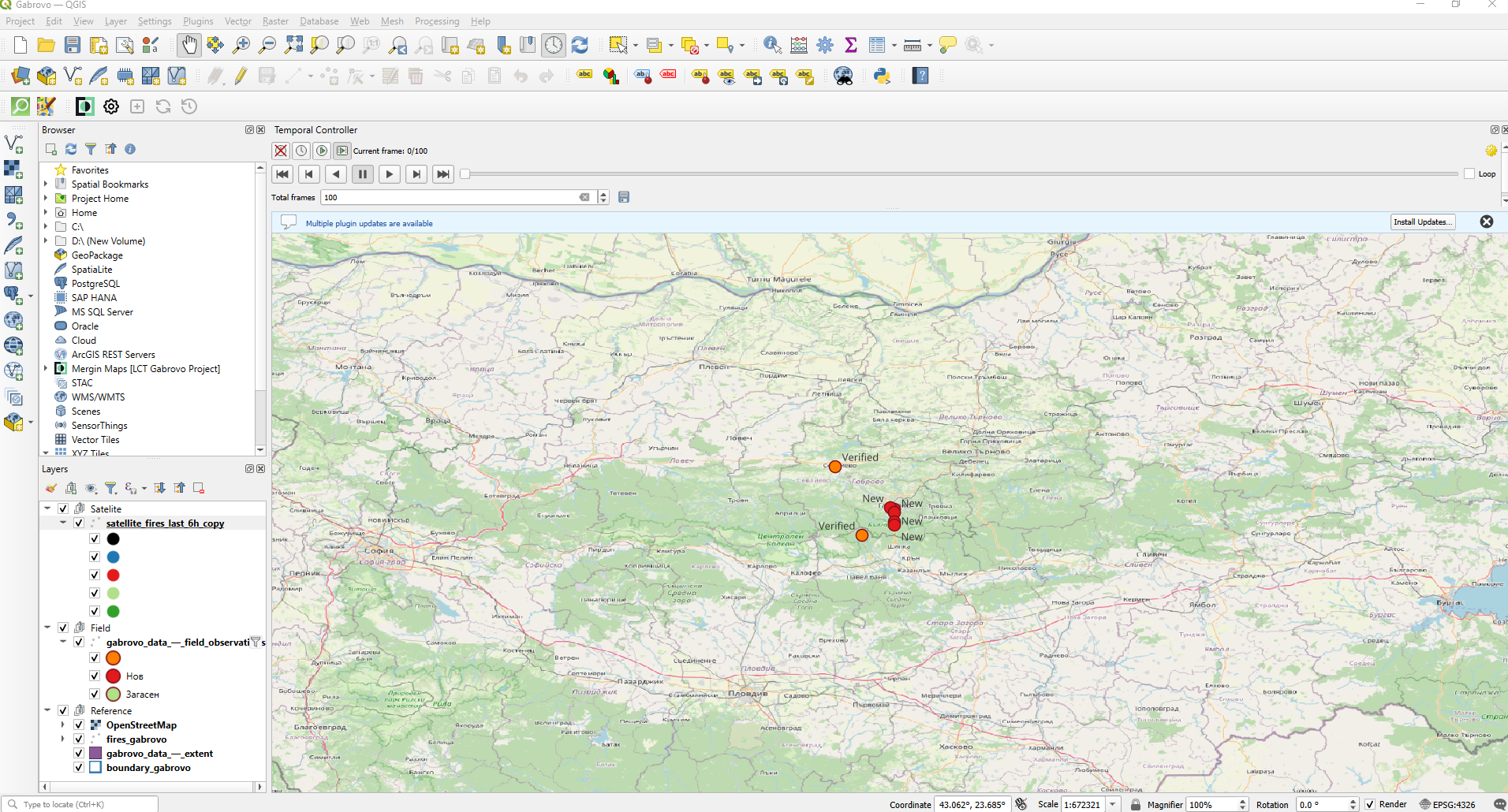
Centralized operational map
The system provides a single operational map where teams can view manually entered incidents, field updates, and satellite-based detections together.
This reduces fragmentation and gives decision-makers a clearer picture of what is happening across the municipality.
Automated satellite fire detections
The solution includes integration with NASA FIRMS (MODIS) as an automated early-warning layer.
Key technical details include a refresh cycle every 15 minutes, filtering by bounding box, conversion into GeoJSON, and hosting through PythonAnywhere for GIS consumption.
Each detection includes useful attributes such as detection time and confidence level, which support verification and prioritization.
Separate workflows for reported incidents and satellite signals
A key design decision was to keep manually reported incidents and satellite detections separate.
This matters because a satellite signal is an indication that may require verification, while a manually entered record is an operational incident report.
To make this distinction immediate, manual incidents are displayed as red points, while satellite detections are displayed as black points. Satellite records also follow a separate verification status flow.
Field data collection and updates
Field teams can work directly from the mobile environment using Mergin. They can submit new incidents, update existing ones, add comments, attach photos, and continue working offline before syncing later.
This makes the workflow much more practical for real terrain conditions.
Offline access in remote areas
An offline MBTiles basemap was included so that teams can continue working even when internet connectivity is weak or unavailable.
That is particularly important for mountainous and remote areas, where wildfire response often takes place.
Field workflow
The field workflow was designed to be simple, structured, and consistent.
Users can create records using predefined types such as fire, smoke, controlled burn, or other. They can also assign statuses, attach images, and add comments to the same incident over time. This helps maintain a clearer operational history and reduces ambiguity in reporting.
Technical highlights
This project is a strong example of combining workflow automation with GIS infrastructure in a way that is operationally useful.
Integration flow
NASA FIRMS data is retrieved through Make.com, the dataset is processed and prepared for GIS use, the output layer is hosted in PythonAnywhere, and QGIS consumes the hosted layer as part of the operational project.
Why this architecture worked well
This approach made it possible to automate recurring satellite updates, avoid manual imports, keep the GIS layer stable and centrally accessible, separate automation logic from GIS delivery, and support both desktop monitoring and field coordination.
Results and practical value
A unified operational picture
Manual reports, field updates, and satellite detections are visible in one GIS workflow.
Faster coordination
Clear distinctions between record types and standardized statuses make review and action easier.
Better situational awareness
Teams can understand where incidents are, how they are progressing, and how field crews relate to them geographically.
Better field usability
Offline maps and offline synchronization make the system usable in real conditions, not just in the office.
Improved early warning capability
The NASA FIRMS layer adds a recurring automated source of possible fire detections, especially valuable in remote areas.
Future enhancements
The solution was implemented to address the municipality’s current operational needs while also leaving room for further development over time. We remain in active communication regarding potential future improvements and additional functionality that could further strengthen incident coordination, field operations, situational awareness, and even support more proactive prevention efforts.
Conclusion
This project demonstrates how municipalities can use GIS, automation, and field collaboration tools together to build a more practical wildfire response workflow.
By combining QGIS, Mergin, Make.com, PythonAnywhere, and NASA FIRMS, the municipality gained a centralized system for incident reporting, monitoring, verification, and coordination.
The result is not just a map, but an operational workflow designed for real response conditions.
Need a similar workflow for your municipality or field operations team?
We design and implement practical GIS and automation solutions that connect field reporting, live operational visibility, and external data sources into one working system.
Get in touch to discuss your use case.